|
//13 de Mayo, 2011 |
Geography |
|
por
equipocadi a las 19:20, en
Geography |
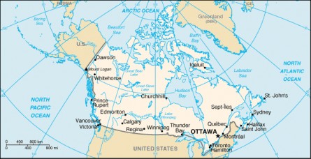
Canada is a federation composed of ten provinces and three territories. In turn, they can be grouped into regions: Western Canada, Central Canada, Atlantic Canada and Northern Canada (the latter is formed by the three territories). Eastern Canada refers to Central Canada and Atlantic Canada together. The provinces have more autonomy than territories, plus they are responsible for most of the country's social programs (such as health care, education and welfare) and together received more revenue than the federal government, an almost unique among federations in the world. However, the federal government who can initiate national policies in provincial areas, such as the Canada Health Act, the provinces can opt for different models of these, but rarely do in practice. Equalization payments are made by the federal government to ensure that they remain reasonably uniform standards of services and taxes among the richest provinces and poorer.
The average temperature in winter and summer varies by location. Winters can be harsh in many regions, particularly in interior provinces and the prairies, where it experiences a continental climate, with average daily temperatures of -15 ° C but can drop below -40 ° C . [124] In the landlocked regions, snow can cover the ground for nearly six months (more in the north). The coast of British Columbia has a temperate climate with a winter warmer but rainy. In the east and west coasts, usually average temperatures do not exceed 20 ° C, while between the coasts the average summer high temperature ranges between 25 and 30 ° C, with occasional heat waves inside exceeding 40 ° C.
The beaver is an animal's own country, to the extent that is considered a symbol nacional.Canadá is also geologically active, as in the country are earthquakes and potentially active volcanoes such as Mount Meager, Mount Garibaldi Mount Cayley and Mount Edziza Volcanic Complex. In 1775, the volcanic cone Tseax caused a disaster, killing 2,000 Nisga'a people of ethnic and causing the destruction of his village in the Nass River Valley in northern British Columbia, the eruption produced a stream of lava of 22.5 kilometers, according to the legend of the Nisga'a, blocked the flow of the Nass River. 
|
|
|
|
Sin comentarios
· Recomendar |
| |
|
|